Features
▶ PPU (Plotter Processing Unit)
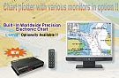
• Separating Display Unit from its Processing Unit, users can choose their preferences for various sizes of Display Unit.
▶ All PC monitors compatible
• Available to use all types of LCD & CRT monitors that support the RGB input.
• Available to use 2 monitors with the common monitor-distributor if necessary.
▶ 2 Types of Chart Systems
• Data provided by the latest built-in digital electronic charts/NAVIONICS® GOLD
▶ Quick & Easy Operation
• High speed CPU engine enables users to work on quick & secure data process.
• The maps stay unchanged in the display change of Zoom-In/Out.
▶ Multi languages
• Korean, English, Simplified/Traditional Chinese, Russian and Greek etc Selectable.
▶ SD Card (Secure Digital)
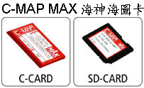
• Available to use SD Card for user’s data backup and program update.
▶ Remote Control
• Wire/wireless remote control, backlight remote control mode,waterproof
▶ External Remote Sensor (Option)
• Easy to install
• Available to remote-control at any user’s wishful locations
Specifications
• GENERAL(Main Unit)
• RGB Signal : All CRT/LCD monitor supported by RGB input Also available to use two monitors with monitor distributor
• Display : 640×480 pixels 256 color
• Power Supply : DC8V~36V
• Power Consumption : below 5W
• Temperature/Humidity : -15℃ ~ +50℃ / 95%(+30℃ ~ +60℃)
• Signal Correction and Tracking : Automation using microcomputer tracking
• Position Precision and Tracking : 15m RMS, PDOP≤3.0(without SA)
• Speed Precision : 0.1 Knots RMS, PDOP≤3.0(without SA)
• Data Recovery Time : 1 Sec.
• Initial Measuring Time : 24 Sec.
• Date Renewal Interval : 1 Sec.
• GPS RECEIVER
• Receiving Frequency : L1 1575.42 ± 1MHz (C/A code)
• Receiving Type : 18 Channels Multi Tracking Type
• Receiving Channel : 18 Channels
• Receiving Ssensitivity : Less than -130dBm
• PLOTTER
• Projection : Mercator drawing
• Display Scale : 0.2 mile ~ 5,000 mile(1/2,500~1/37,500,000)
• Effective Display Range : below 85° of latitude
• Display Mode : true-motion, course-up, north-up, head-up function
• Tracking Memory Interval : 1sec~60minute(0.01~9,99NM) set-up
• Tracking capacity : 20,000 points, Event mark : 21 kinds Mark ,capacity : 10,000 points
capacity for user’s drawing of shoreline : 8,000points 16 land coloring
capacity for user’s marking of shoreline : 1,000points
capacity for user’s character of shoreline : 1,000points
capacity for tracking marking : 1,000points
capacity for memory of destination : 1,000points
capacity for memory of route : 20 routes (20 points/1 route)
• Alarm : 1)arriving alarm 2)off-course alarm 3)anchor alarm 4)boundary alarm
• Interface : SAMYUNG, NMEA0183, FURUNO(CIF), JRC







 SAMYUNG 三榮GP-330 15吋液晶雙海圖分離式電子海圖GPS